Hermine Triggers Weather Advisories Along the Atlantic Coast – ‘Dangerous Storm Surge’ Forecasted
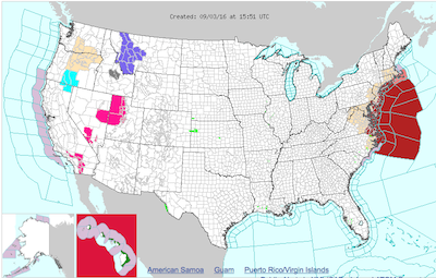
 Hermine's path is the red mass along the east coast, as her wrath overtakes the coast in its post-tropical cyclone form. Image courtesy of the National Weather Service.
The National Weather Service is calling for “dangerous storm surge expected along the coast from Virginia to New Jersey…”
“Hermine,” which has now been classified as a “Post-Tropical Cyclone,” has been triggering advisories for locations along the Eastern seaboard.
At 11 a.m. today, the National Weather Service, in addition to its summary for the areas from Virginia through New Jersey, spelled out some changes.
A Tropical Storm Warning for:
- Sandy Hook, NJ
- Long Island
- Long Island Sound
- New York City
- Watch Hill, RI
- Ocracoke Inlet, NC
- Pamlico Sound, NC
- Albemarle Sound, NC
- Chesapeake Bay
- Drum Point, MD southward
- Tidal Potamac
- Cobb Island, MD and eastward
- Delaware Bay
Additionally, a Tropical Storm Watch has been issued for:
- Watch Hill, RI
- Sagamore Beach, Mass.
- Block Island
- Martha’s Vineyard
- Nantucket
- Cape Cod
When the National Weather Service update was release, Hermine was located offshore of the Outer Banks along the North Carolina Coast, heading east and northeast at about 15 mph. Hermine will exit the North Carolina coastline by Monday morning, and make its way towards the Delmarva Peninsula (Delaware/Maryland/Virginia).
Wind gusts have been reported between 44 mph and 73 mph at varying locations. The maximum average wind speed expected will be about 65 mph.
The National Weather Service describes the anticipated storm surge coming to places like Sandy Hook as “large and dangerous waves,” with a “danger of life threatening inundation during the next few hours in the Hampton Roads [North Carolina and Virginia] region, and in the next 36 from Chincoteague, Virginia to Sandy Hook, New Jersey.”
The National Weather Service suggests that there will be life=threatening inundation during the next 48 hours between Sandy Hook and Bridgport, Conn.
“Persons within these areas should take all necessary actions to protect life and property from rising water,” the outlook added. “Promptly follow all instructions, including evacuation orders, from local officials.”
Peak surges at high tide are expected at:
- North Carolina coast – one to three feet
- Hampton Roads – three to five feet
- Chincoteague through Sandy Hook – three to five feet
- Sandy Hook to Bridgeport – two to four feet
Hermine will leave Virginia and Maryland with about four to seven inches of rain, with about one to four inches along Eastern New Jersey, Southern Delaware and Long Island by Monday.
The local news stations including WAVY has provided images of the wrath that Hermine is already causing in Hampton Roads, including an overturned tractor trailer on the Alligator Bridge, with its cab crumpled. Below is a video from Joe Fisher of WAVY.
Alligator River Bridge, connecting #Dare and #Tyrrell counties, closed after tractor-trailer accident. @WAVY_News pic.twitter.com/cg52JiM0JV
— Joe Fisher (@JoeFisherTV) September 3, 2016
The High Rise Bridge also suffered a jack-knifed tractor trailer during the weather event.
The article provides embedded video footage from the City of Hampton’s Police Chief of the storm surge. It is below from the Fort Monroe sea wall in Virginia.
Take a ride on the Fort Monroe sea wall with the Police Chief. (Don’t try yourself!) pic.twitter.com/ncSbWb37Ov
— City of Hampton (@cityofhampton) September 3, 2016
The Richmond Times-Dispatch has noted that Hermine has left 58,000 residents without power in the region of Virginia’s southeast.
Stay on the scene with Inside Scene as we continue to track this storm. Click here to “like” us on Facebook.


Leave a comment
You must be logged in to post a comment.