The Aftermath of ‘Winter Storm Jonas’
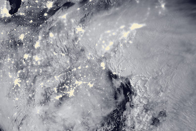
 Winter Storm "Jonas" blankets the entire Northeast as well as part of the Great Lakes in this NASA Public Domain image captured on Jan. 23, 2016.
NEW JERSEY – The snow has stopped falling throughout the Northeastern region that was paralyzed from the Winter Storm Warning that changed to a Blizzard Warning throughout many areas on Sat, Jan. 23.
Some meteorologists are coining the storm in some locations as “historic” because of its global impact, especially because of the simultaneous blizzards happening in major cities at once, including New York, Baltimore and Washington DC.
For many locations, the storm itself was “record breaking,” and even in some cases, even greater than the storm that shut down the Northeast two decades earlier, known as the “Blizzard of ’96.” These cities are: Allentown Pennsylvania (in 1996 the storm dumped 25.9 inches and yesterday reached 31.9 inches), Baltimore and DC (received 29.2 inches, which was more than the President’s Day storm in 2003), Harrisburg Pennsylvania (Since 1983, the previous record was 25 inches, and now is 30.2 inches from this storm), New York (the President’s Day storm in 2003 was 26 inches and this time was 30.5), and Newark (the Blizzard of 1996 dropped 27.8 inches and on Jan. 22 and 23 the blizzard left Newark to shovel 27.9 inches).
The cities that received the greatest snowfall in the Northeast during the storm were:
- Glengary West Virginia – 42 inches
- Philomont Virginia – 39 inches
- Redhouse Maryland – 38 inches
- Port Richmond New York – 31.3 inches
- Morris Plains New Jersey – 33 inches
- Woodside Delaware – 17.2 inches
- Norwalk Connecticut – 16 inches
- Westerly Rhode Island – 15.5 inches
- West Harwich Massachusetts – 15.5 inches
The areas that have dealt with a crippling blow of another kind from this storm are coastal sections of New Jersey and Delaware. Though the National Weather Service issued “Coastal Flood Warnings,” during the height of Winter Storm Jonas, evacuations were called for in many areas, with the Coastal Flood Warning in effect through noon today. Flood totals were greater than those when Superstorm Sandy hit New Jersey in 2012, with 10 and 15 feet of water careening through streets of locations including Wildwood and Cape May. During Sandy, high tide was 8.67 and the record from this storm on Saturday clocked in at 9.26.
The storm is anticipated to make its way out to sea and head to the United Kingdom between Jan. 26 and 28, bringing significant rain and local flooding.
Stay on the scene with Inside Scene. Click here to follow all of our stories on Facebook.


Leave a comment
You must be logged in to post a comment.